During the First World War, my grandfather Richard Little fought at the Battle of Loos with the 10th Battalion York & Lancaster Regiment. This month, almost a hundred years ago to the day, my son Max and I visited the battlefield:
My experience of France is very different to that of my immediate ancestors.
My father's first step on French soil wasn't from the car ferry at Calais, it was onto a beach in Normandy in 1944 and all his time in the country was spent worrying about stepping on or driving over a mine; being shelled or mortared; bombed, machine-gunned or sniped. Not what you'd call a great holiday!
My grandfather's experience was even worse - you can add poison gas to the list of ways to be killed.
A traffic jam on the Boulevard Peripherique or being diverted onto the tunnel because striking fishermen have blockaded Calais harbour is not in the same league. This month, Max and I enjoyed a couple of days in Artois region in north-east France visiting the area where my grandfather fought during The Great War and this post is about our experience.
My grandfather fought in the Battle of Loos in September 1915. The mass killings of the Somme, which were to see the worst casualty figures ever suffered by the British army, were still almost a year away, but in many ways, Loos was a dress rehearsal: it was to be the big breakthrough, it was fought to relieve pressure on the French and the plan was broadly the same - hurl thousands of infantry at heavily defended German positions.
In 1915, Loos was the most bloody battle the British Army had fought. It cost over 20,000 lives and 8,500 men were killed on the first day - the worst casualty figures sustained to that date. If the First World War had ended there and then, we'd view Loos like a modern-day Waterloo, unbelieveable casualty figures and a horror etched on the nation's psyche. Sadly, no lessons were learned from Loos and it was followed by the Somme and by Paschendale - battles bigger in scale and battles where many more men were wasted.
I'm not reopening the 'Donkeys' debate from my post How Haig Tried to Kill My Grandfather but just so you know where I stand: my view is that Haig was criminally incompetent and needlessly wasted thousands and thousands of lives.
Through battalion and brigade war diaries, history books and biographies, I have been able to piece together my grandfather's experience of going into action for the first time and now I wanted to see the ground where this dreadful battle took place, but in particular the area of the battlefield around Loos-en-Gohelle, just north of Lens, which is where my grandfather was.
It's easy to access from my home near Peterborough - a two-and-a-half hour drive to Dover, ferry crossing and then an hour from Calais (autoroute all the way to Lens). We stayed at the Campanile Lens, which is on the Lens northern ring-road and well placed for Loos and the countryside beyond. We also took bicycles as a good way to get around the battlefield and allow us to feel in touch with the land.
Richard Little, my grandfather, had reached Loos by a very different route. He landed in Boulogne and after a series of night marches (for secrecy) his battalion arrived at Vermelles on the first day of the battle (September 25, 1915). He approached Loos along the Bethune/Lens road, crossing the old German front line and, at the site of the Lens Road Redoubt (a German strong-point taken earlier in the day), they turned off the road and headed across open country, skirting to the north of Loos and then heading east to take positions in the new front line along the Lens/Hulluch road, occupying Chalk Pit Wood, The Chalk Pit, Puits 14 (a coalmine), Bois Hugo wood and the line of the road itself.
Their left flank was open, to their front was Bois Hugo (partly held by the British) and on their right flank was another wood (Chalet Wood) held by the Cameron Highlanders and, beyond that was Hill 70. We'd gained a foothold on Hill 70 during the first day's fighting, but battalions which had attacked it were already decimated after attacking the German front lines and then clearing the village of Loos, so consequently the key target - a redoubt built on the side of the hill and overlooking the battlefield - was still in German hands.
On September 26, 1915 there was a strong German counter-attack which drove the Camerons out of Chalet Wood and 63 Brigade out of Bois Hugo. They attempted to hold the line along the Lens/Hulluch road and Puits 14, but were driven back. An attack on Hill 70 had been a complete fiasco, so they were under fire from machine guns on the hill. from Bois Hugo and Chalet Wood and by German artillery. They were driven back to the west and formed a defensive line along a track running north from Loos. Several counter attacks were made during the afternoon, but the open countryside dominated by enemy positions meant they suffered dreadful losses.
To the north of Chalk Pit and Bois Hugo, there was a mass attack against the German Second Line. This was made with little artillery support, against German strongpoints with uncut wire. The site chosen for the attack was enfiladed by fire from Hill 70, Bois Hugo and Hulluch and the men attacked in close formation, marching across the fields. There were more than 2,500 casualties and the land was known as "Leichenfeld von Loos" by the Germans and simply "Field of Corpses" by the British.
During the early hours of September 27, my grandafther's battalion was relieved by Guards battalions. A third of them had been killed.
On September 27, the Guards attacked to try to retake Chalk Pit Wood and Puits 14, but were also massacred. Among the dead was Lt John Kipling, the son and only child of author and poet Rudyard Kipling. There were other attacks into October 1915, but no further gains. Loos remained in British hands, but the village was a ruin, shelled to rubble.
A hundred years later, the land is peaceful, with people just getting on with their daily lives. Apart from the many military cemeteries and the substantial war memorials in surrounding communities, you wouldn't know what dreadful battles had been fought here.
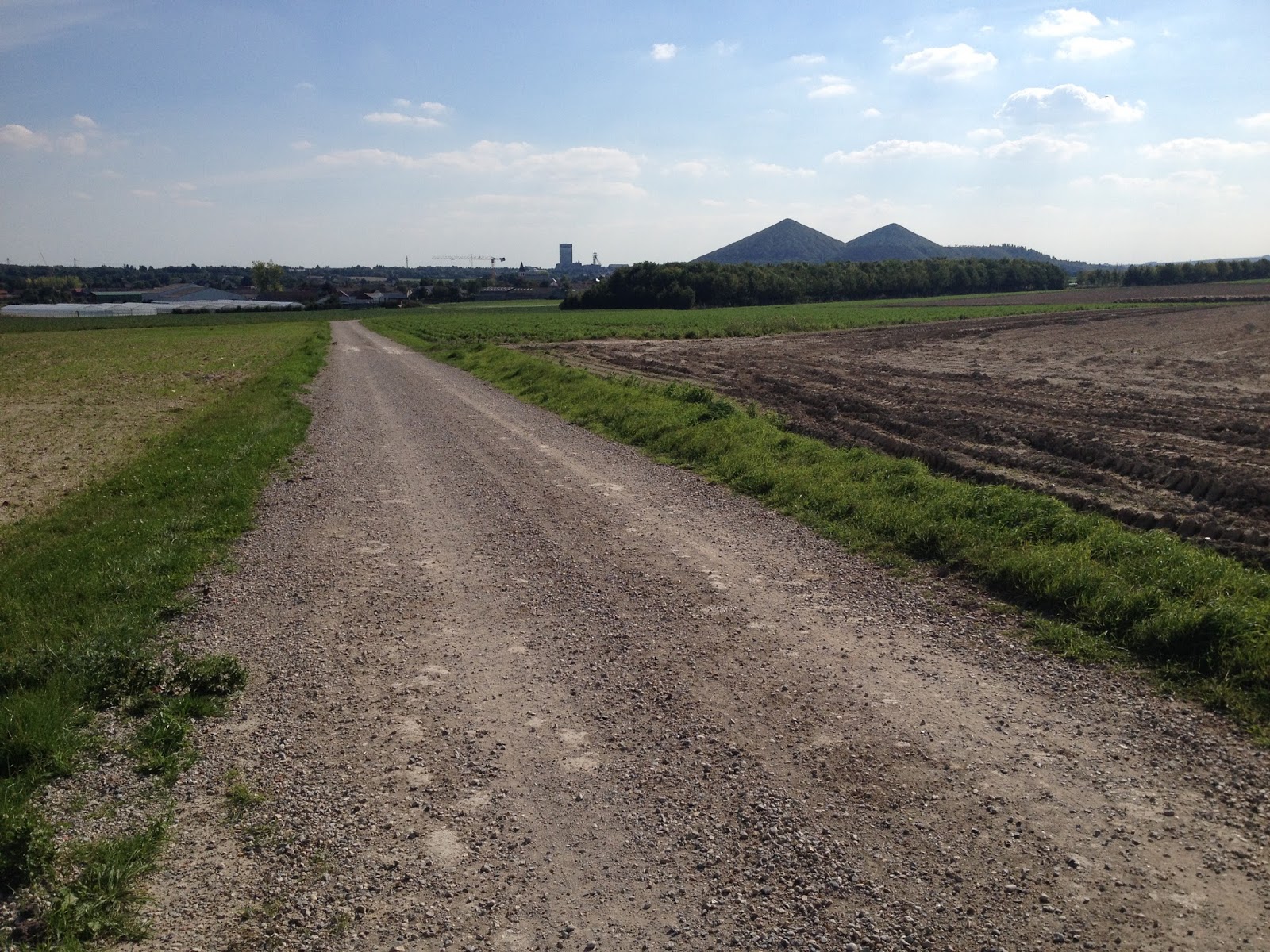
The land is gently undulating, with a dip into the Gohelle valley where Loos sits and then up again as you head east. The land falls more sharply to the south as you descend into Lens. It was once a major coalfield, but it's now a post-industrial landscape with many slag-heaps. greened over, but still dominating the area. Fields are wide, with no hedges; there are pockets of woodland and the ground is clay over chalk.
 |
| View across the valley towards Loos from the Lens/Hulluch road. I am standing on the line reached by British troops on September 25, 1915. |
It was surprising how familiar it was to me. Having read umpteen accounts of the battle and studied war diaries, I was able to orientate myself very easily and recognise landmarks immediately. What did surprise me was the scale, it was far more compact than I expected - Chalet Wood and what's left of Bois Hugo are only a narrow field apart. You can appreciate how devastating enfilade fire would have been from such close quarters.
Most things are not that different to 1915. There's a new ring road between Loos and Lens (the A21); some slag-heaps have been reduced, others are bigger; Hill 70 now has a prison on its northern flank and an estate of light industry around its eastern edge, while the A21 makes a deep cutting along its southern edge. Chalet Wood looks untouched, but Bois Hugo is much reduced.
Our hotel was just off the ring road and on the southern flank of Hill 70. It's bizarre to find myself sleeping and eating on land where thousands of men died trying to occupy it. All I did was drive up and check in. Well, in fact, it wasn't that easy - when we arrived the slip-road off the A21 had been closed and so we had to skirt around through Loos and approach from the direction of Hulluch, only to find police blocking the access road. We think there may have been a problem at the prison (perhaps a break-out?) but we couldn't get in, so we drove into Loos and parked up in front of the mairie. The police had said it would be an hour, so we did what any chap would do and went for a beer.
 |
| The main square in Loos and the Mairie. |
There's a cafe on the corner of the square at the end of Rue 11 November 1918 and they were friendly, but not with good English. This is not a tourist area, so a smattering of French is very useful. Anyway, I 'voudrayed' a couple of beers and the proprietor, somehow sensing I was English, delivered me a couple of leaflets for the museum. This had a map of the battle on day 1 and also contacts for the museum, which is behind the town hall and open by appointment.
After our drink, we walked down to the Loos British Cemetery. It's the first time I have stood in a First World War cemetery and it's hard to relate this beautifully kept, manicured, place with the horrific events of 1915. There are 3,000 graves in the cemetery and the majority of them are unidentified. The army didn't provide 'dog tags' or any means of identifying bodies at this stage of the war and the cemetery was established in 1917 when it was used to create permanent graves for dead soldiers buried in makeshift graves around the battlefield. Many of these would have been buried in haste and subsequent decomposition meant recognition would have been impossible. Some regiments are identified by badges or buttons, but individuals remain unknown unless their rank singled them out. As a consequence, most graves simply bear the line written by Rudyard Kipling: A Soldier of the Great War - Known Unto God.
 |
| An example of a "believed to be buried" headstone |
This was clearly very distressing for the relatives of soldiers posted as 'missing', who wanted to know where their loved one's body was lying. This cemetery, and others we visited during the next couple of days, had a number of memorial plaques to individuals giving a name, rank and regiment with the line: "Believed to be Buried in This Cemetery."
From a modern perspective, it shows how little respect the army had for its common soldiers that they were prepared to sacrifice so many lives so carelessly and then, even in death, the individuals were simply 'processed' without proper recognition. To me, the 'respect' now shown to these badly treated men in the form of beautiful, impeccably maintained cemeteries and memorials seems incongruous.
Their lives were wasted by incompetent commanders; they were slaughtered by shell and machine gun, often left lying on the battlefield for years reblasted by subsequent shells; then the bits were gathered together and buried in immaculate cemeteries, their graves marked by white marble headstones in rows so straight they could be laser drawn. It seems too little, too late, not in keeping with the way the men were treated in life. It's a post war apology to try to distract from a litany of incompetence; it glorifies a war that was anything but glorious.
 |
| Neat lines of graves in the British Cemetery in Loos - most of the headstones mark unknown graves. |
There were a couple of hours before dinner, so I suggested to Max that we walk into Lens and take a look around. The road runs steadily downhill into the town. The outer suburbs are not particularly attractive, but there's a new football stadium being built (Lens is one of the sites for Euro 2016). The town was under German occupation during the war and, being pretty much on the front line, it was heavily shelled. We walked up the main street and every lamp-post has a speaker attached from which they were playing music. It sounded a bit like Gold FM - very strange. There was a biker cafe, with a mixture of sports bikes, cruisers and a couple of Ural combinations parked up. The bikes were an odd mix but the riders had gone for a universal Hell's Angel look. We walked on to the main square and had a beer in the sunshine. There's a fine church which bears a plaque to say it was rebuilt in the 1920s after being destroyed in the Great War.
We were back at our hotel by 7.30pm and time for a nice dinner. Odd to think that we'd walked into Lens in just over half an hour - something it took the Allies four years to achieve.
Next morning was bright and sunny, barely a cloud in the sky and with a light easterly breeze. Back in September 1915, it had started raining pretty much as soon as the battle began and my grandfather's battalion would have been soaking wet by the time they took up their positions. Anyway, this was a good day for cycling.
According to Major and Mrs Holt's Battlefield Guide, the roundabout where the hotel, prison and industrial area are joined to the Lens/Hulluch road was the site of the Hill 70 Redoubt and standing there on a clear day, you can see for miles across the surrounding countryside. It's not a large hill (and wouldn't even be noticed in Derbyshire), but in this flat, open landscape you can appreciate what strategic importance it had in 1915.
I said before that the landscape was familiar to me from the reading I'd been doing, but also how much smaller and compressed it was in reality. From the Redoubt (roundabout), we rode down the hill towards Hulluch and the area where my grandfather had been in action.
Chalet Wood is reached in a couple of hundred metres. This had been taken and occupied by the Cameron Highlanders on September 25. In the German counter-attack the following day, this was the first ground wrested back and the Camerons were killed almost to a man. The shape and size of the wood seems the same as 100 years ago.
 |
| Puits 14 - the winding gear has gone and the shaft sealed. These buildings were certainly built after the Great War. This was the scene of bitter fighting in 1915. |
Bois Hugo is much reduced. An airfield has taken out the corner near the road and a supermarket has been built in the middle, with a new roundabout and a road along the wood's southern edge. When they were digging the ground to put in the new roundabout, a couple of bodies were discovered just below the surface. They were identified by their buttons as being from the Cameron Highlanders. After extensive research, one of the bodies was identified using DNA technology as L/Cpl John Brown. He was buried in the Loos British Cemetery (the one we visited the previous day) in 2004. Ironically, he's one of the few from his battalion to be identified.
We continued along the Lens/Hulluch road past the Chalk Pit on our left. The wood here is much smaller than in 1915 and the pit itself seems much bigger. After the Chalk Pit, the terrain opens out at the bottom of the valley, with wide fields on both sides. This is much like it was in 1915 and this is the ground where, on September 26, 1915, men of XI Brigade marched in formation (like a parade at Aldershot, according to one observer) towards the German second line. We stopped our cycles as if to let them cross the road ahead of us. To the right, this open ground was a killing field - the Field of Corpses - a hundred years ago. Bathed in the sun of a late summer morning, it's hard to imagine what happened here.
The Germans had the high ground immediately on the right and left flanks of the attacking British and two strongpoints - Stutzpunkt III and IV were immediately ahead. It's hard to think of a more unsuitable place to launch a mass attack or a more inept way to conduct it. The men would have marched past the York and Lancaster's left flank - my grandfather would probably have witnessed the whole bloody catastrophe.
We rode on towards Hulluch with the ground rising gently. At Hulluch, we turned west along the road to Vermelles. To our right (north) are The Quarries, The Dump and the Hohenzollern Redoubt, all the scene of bitter (and ultimately fruitless) fighting. The Queen Mother’s brother, Fergus Bowes Lyon was killed at The Quarries and, like many others, his grave isn’t marked. So when Elizabeth Bowes Lyon married The Duke of York (later George VI) at Westminster Abbey in 1923 she paused on her way into the cathedral to lay her wedding bouquet on the grave of the Unknown Warrior, who represented the thousands and thousands of soldiers with no known grave. This started a tradition with bouquets from royal weddings laid on the tomb the day after the wedding, the latest being Kate Middleton's.
From Hulluch to Vermelles, the road slopes down and then up as it crosses the shallow valley. On the left, towards the valley floor are three cemeteries - St Mary's, Ninth Avenue and Bois Carre all lying across what was the old German front line in 1915. We stopped at St Mary's, which was the site of an advanced dressing station. It must have been an unbelievably horrific place in the autumn of 1915.
 |
| St Mary's ADC Cemetery. |
Like all the others, it is impeccably maintained, but 90 per cent of the graves are unidentified - an indication of the chaos of the battle. One grave that is marked is that of Lt John Kipling, the son of author and poet Rudyard Kipling. John was killed on September 27. His battalion was one of a number who relieved 63 Brigade in the early hours of September 27. He was killed by Chalk Pit Wood, where my grandfather had fought the previous day, and his body lost. Rudyard Kipling spent much time trying to find the body of his son and it was only in 1992 that the Commonwealth War Graves Commission decided they had positively identified a body as that of John Kipling. The identification was on the basis that it was right rank and regiment and that only one soldier of that rank and regiment had been killed. The identification is contested by some, but I can't see that it matters that much after all this time.
 |
| The grave of John Kipling in St Mary's cemetery. |
My Boy Jack by Rudyard Kipling
“Have you news of my boy Jack?”
Not this tide.
“When d’you think that he’ll come back?”
Not with this wind blowing, and this tide.
“Has any one else had word of him?”
Not this tide.
For what is sunk will hardly swim,
Not with this wind blowing, and this tide.
“Oh, dear, what comfort can I find?”
None this tide,
Nor any tide,
Except he did not shame his kind —
Not even with that wind blowing, and that tide.
Then hold your head up all the more,
This tide,
And every tide;
Because he was the son you bore,
And gave to that wind blowing and that tide!
We rode on along the Vermelles and then made our way via back roads to Annequin, where we picked up the main road to Bethune. This was quite a busy road, but French drivers are a little more considerate to cyclists than British drivers and there was also a hard shoulder we could use for most of the route.
I wanted to visit Bethune because it is mentioned frequently in Goodbye To All That, Robert Graves' memoire of the First World War, which I highly recommend.
 |
| The bell tower in the centre of Bethune in 1918. |
Bethune was a beautiful mediaeval town and remained in Allied hands throughout the war. It was flattened by high explosive and gas shells, also bombed by Gothas during the 1918 Spring Offensive or Kaiserschlacht (Kaiser's Battle), which was the German's last attempt to break through Allied lines and win the war. In the 1920s, the town was rebuilt as closely as possible to the original. We cycled into the centre where there is a square with the old bell tower. This wonderful tower was still standing, although heavily damaged, in 1918 and is now fully restored. We sat and had a beer in the sun and listened to the bells, which chime quite a complicated tune every quarter and really let loose on the hour. Max wondered what Richard Little would have thought. I'm sure he would have appreciated the timeless delights of beer and a smoke with his grandson and great-grandson.
 |
| Beer in Bethune. |

From Bethune, we headed back to Annequin, but managed to take back roads through the suburbs and avoid the busy N41 for most of the way. In 1915 Annequin was the site of the principal British artillery observation post, positioned at the top of a slagheap 135 feet high. The heap has now been reduced and Annequin is a very pleasant village when you get away from the main road.
 |
| Mini statue of liberty in Cambrin |
I once had a photographer colleague whose job, at the end of the Second World War, had been to photograph graves of soldiers killed in Italy. He'd photographed all the headstones at Monte Casino and had used a special camera body that held a roll of film with 200 frames. he then had to develop the film and print each frame, so it could be sent to relatives of the dead man. His job would have been a heck of a lot easier with a digital camera.
Cambrin contains the grave of Capt A L Samson of the Royal Welch Fusliers, a friend of Robert Graves, who was killed on the first day of the battle. In Goodbye To All That, Graves writes how he waited in the trenches while the first wave went over. The men were cut down by murderous machine-gun fire and that other men, hearing the cries of the wounded only yards from the trench tried to help, but were also shot. Capt Samson had been shot 17 times and had forced his knuckles into his mouth to stop him crying out in his pain and attracting more men to their deaths. Graves wrote the poem The Dead Fox Hunter in Samson's memory:
We found the little captain at the head
His men lay, well aligned.
We touched his hand - stone cold - and he was dead,
And they, all dead, behind
Had never reached their goal, but they died well.
They charged in line, and, in the same line, fell.
There was no progress in this part of the battlefield in 1915 and soldiers were occupying exactly the same trenches in 1918.
Cambrin has an unusual war memorial. It is an exact copy (scaled down) of the Statue of Liberty and was erected in 1926 following a lottery that raised 35,000 francs. Originally, the memorial was sited on the main road in front of the Mairie, but it has now been repositioned in a new village square adjacent to the church. It's a much better position away from the busy road.
After 15 miles or so of cycling, I was now feeling quite saddle sore.
We pressed on along the road towards Auchy, but then turned off along a minor road across country towards Vermelles. This took us back across the old German front line and into the valley to Vermelles - a nice downhill freewheel. A bicycle is a great way to get around the battlefield. You can stop and park at will and you're aware of all the rises and falls of the terrain.
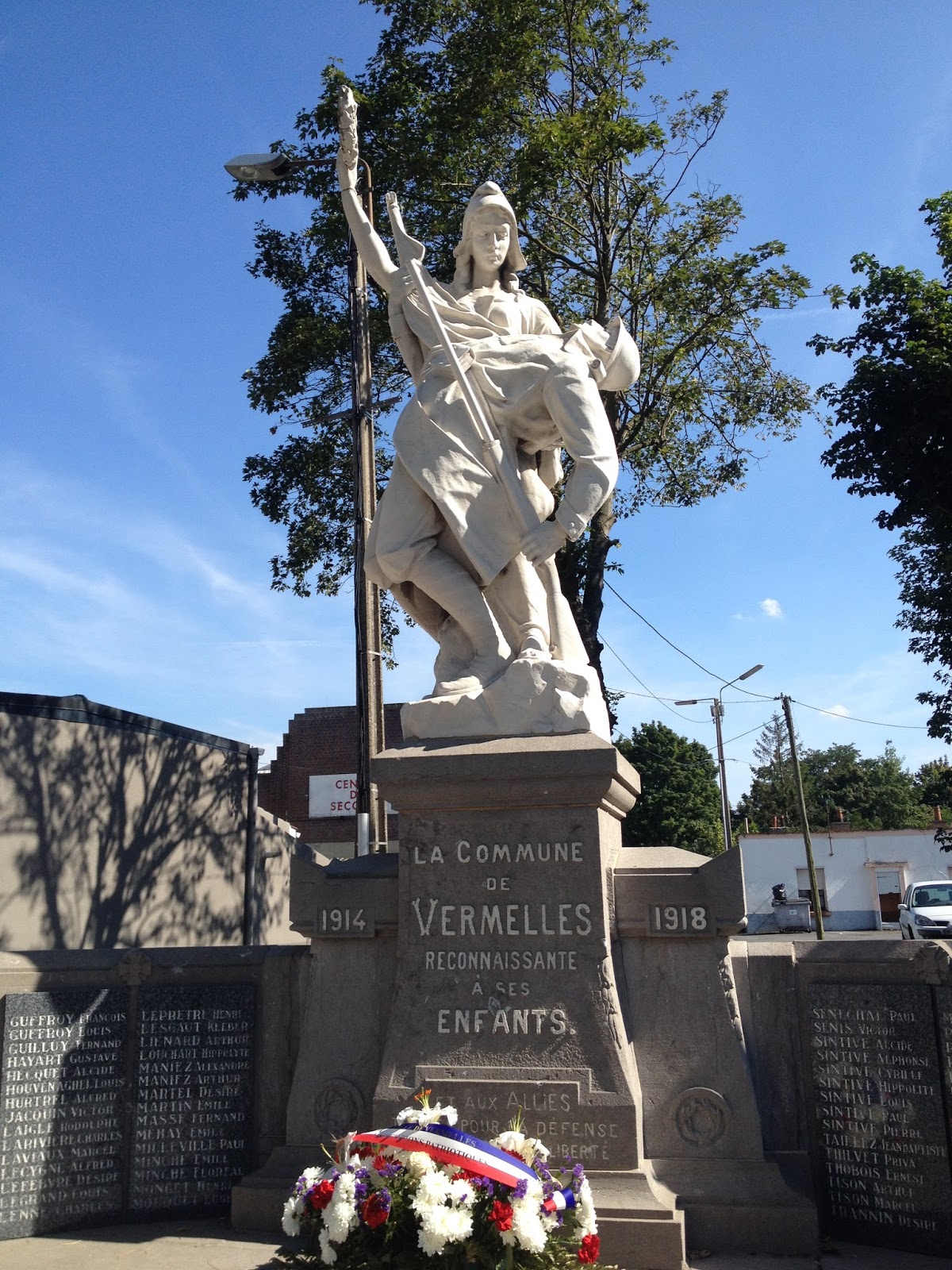 |
| War memorial in Vermelles |
From the centre of Vermelles, we reversed the route we had taken that morning to St Mary's Cemetery. Just to the east of the cemetery, a track runs across country in the direction of Loos and I wanted to follow this back into the village. In the war diary of the 10th Battalion York & Lancaster Regiment it describes the battles of September 26 and as the men are beaten back from the Chalk Pit and Lens/Hulluch road, they reform with other battalions along the line of a track running north from Loos and mount a number of attacks to try to win back the Chalk Pit and Puits 14.
I couldn't say this track was that same track, but I wanted to see and I think there's a good chance that it was; or at least it was very close to the line. From St Mary's we walked uphill with a tiny cemetery (Ninth Avenue) and a larger one (Bois Carre) on our right some 50 yards off the track. Looking west, you can see the Lone Tree. This was a tree in no man's land which was a landmark during the battle. In 1995, a cherry tree was planted in place of the original tree and it bears an inscription in English, French and German: "Lone Tree, replanted in memory of all those who lost their lives in the Battle of Loos."

 |
| On the track running north from Loos. I think my grandfather would have crossed this track in the early hours of September 25, 1915, moving up to the front line; then retreated back to it the following afternoon as the Germans counter-attacked and won back ground. |
As the track sloped down towards Loos, we spotted a figure running across the fields towards us. It was a jogger, keeping his fitness levels up. He's running for his life, just as so many were a hundred years ago. Across to our right, we waved at a tractor driver ploughing in the stubble and a little further on an old man was scavenging for onions in a field recently harvested. He had a pretty decent bag full that the harvester had missed.
Back in Loos, there was time for a drink in the cafe on the main square. That last ride up the hill to the hotel (Hill 70) was quite a haul with my tired legs.
I had e-mailed the Alexandre Villedieu Loos War Museum to arrange for it to be opened for us on Friday morning. They were very efficient, had replied promptly and we were to meet M Duparcq, president of the Loos Great War Association at 9.30am. He was a smart old chap, very friendly, but with little English. However, with his little English and my little French, plus some mimes, we just about managed to get by.
It's an interesting little museum occupying two large rooms and a landing on the second floor behind the Mairie. There are weapons, detritus from the battlefield and some displays of maps. There's a French soldier in the uniform used by troops during 1915 when the French tried to liberate Loos. They wore red trousers, a blue coat and a red cap - they might as well have painted a target on their chests. There was also a display of trench mortars, an evil-looking club used by German troops for trench fighting and a collection of hand grenades. There's a Mills bomb with instructions, telling the user that he could pull the pin but keep the handle clasped and "throw at your convenience". That seems inappropriately quaint writing for such a deadly device. Mills bombs were quite rare during Loos, most soldiers had to use bombs with a fuse which had to be lit with a match (there was an example of one of these). They were pretty much useless when it rained (and it was raining on September 25, 26 and 27 1915).
 |
| Trench mortar bombs in Loos museum. These could contain shrapnel or poison gas. |
There was a display on John Kipling, on the bodies found when the roundabout was being constructed and on Emilienne Moreau, a young woman living in Loos, who warned soldiers of the Black Watch of an ambush and who also helped tend to wounded men in the village. I asked M Duparcq where the Hill 70 Redoubt was sited and he showed me an aerial photograph from modern times upon which features could be seen marked by chalk raised to the surface. His position was somewhat to the west of the Lens/Hulluch road and not on the roundabout as stated in Major and Mrs Holt's Battlefield Guide.
 |
| Climbing the slagheap - hard work, but the view is impressive. |
I'd seen a footpath marked on a map at the Mairie, so we took a picture of it for reference and set off. The path took a bit of finding, but we got there. The walk up was very steep, but at the steepest point, near the top, there are some steel ropes fixed into the earth, which you can use to help you pull yourself up (and down). The view from the top is magnificent. They are 180 metres high, so the height flattens the contours of the land below and makes it appear more even than it is, but you can see across to Lens, over the whole battlefield and towards Bethune, shrouded in haze.

The cemetery is on the site of the Lens Road redoubt, a German strongpoint taken on the first day of the battle. The site was nicknamed Dud Corner by British soldiers due to the large number of shells which had failed to explode during the bombardment. My grandfather had marched down this road from Vermelles and they had turned off the road at this point and marched across open country, skirting north of Loos which was burning in the night sky to take up their positions in the early hours.
This is the one point in the whole battlefield where I can say for sure that my grandfather had passed.
That was the end of our tour. For us, it was a short ride back into Loos, a drink and some lunch from the 8 a Huit, back to the hotel to collect the car and a short drive back to Calais. All a far cry from 1915.

 |
| The British Memorial at Dud Corner. It has the names of all those who died at Loos and have no known grave. Below: I found the first graves of York & Lancaster Regiment soldiers, but they were only "Known Unto God" |

No comments:
Post a Comment